search
Los Angeles metro map
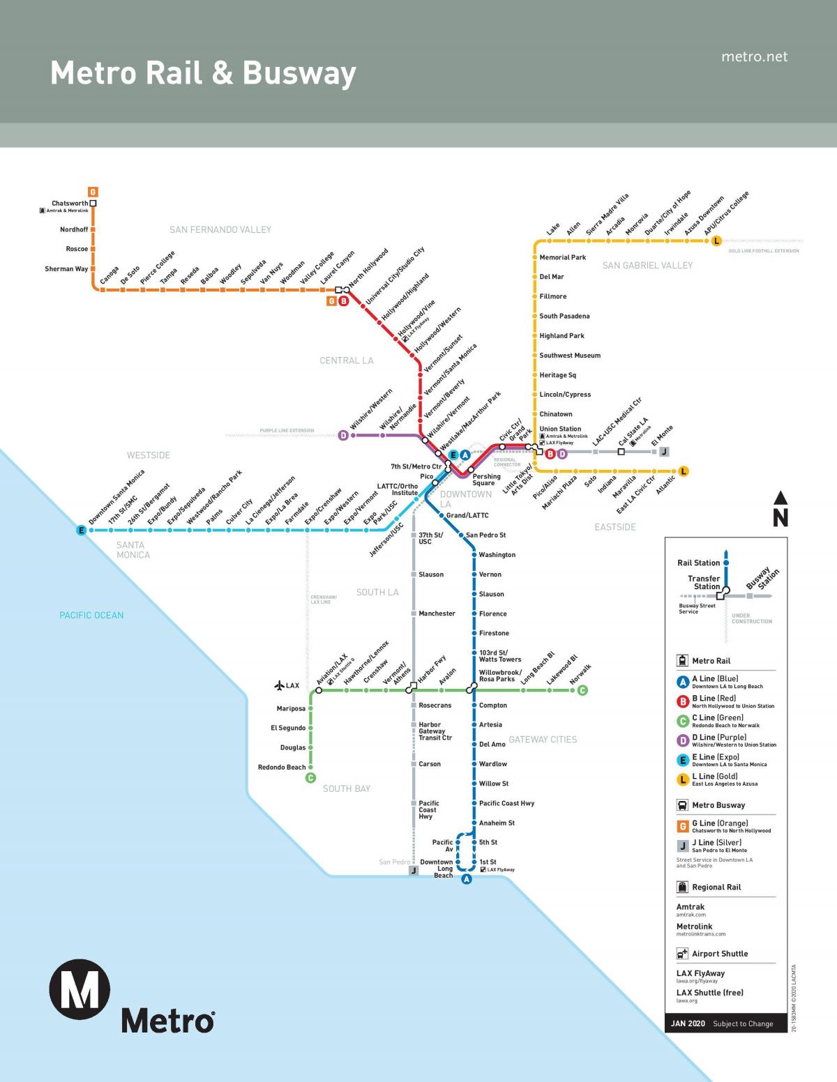
Metro map Los Angeles. Los Angeles metro map (California - USA) to print. Los Angeles metro map (California - USA) to download. At Union Station at Los Angeles metro map, MTA Bus Control, Gateway Plaza, Downtown. Access either through the east entrance to Los Angeles Union Station (on Vignes St), or through the underground if you are arriving through the main entrance to the station (on Alameda St). Monday to Friday 6.00am-6.30pm. You will be able to get the Los Angeles metro network map (which will require a great deal of concentration to read), timetables and all-inclusive tickets.
As it shows in the map Los Angeles metro rail has 6 lines: the Red Line, Blue Line, Green Line, Gold Line and Purple Line; the last one, Expo Line, connects Downtown to Santa Monica via Culver City). These "Los Angeles Metro Rail Lines" are complemented by 2 "Metro Liner" lines (Orange Line and Silver Line), which are in fact buses with the look and feel of a subway train and function like it (stop at each Los Angeles station, enter through the desired door, tickets only sold in vending machines, etc.).
By the beginning of the 21st century the MTA had completed a subway between Union Station downtown and North Hollywood and several of the light-rail lines. Additional subway and rail lines of Los Angeles were planned or under construction. The MTA also operates transitway buses (which follow dedicated bus roads, thus avoiding traffic problems) and Metro Rapid express bus service along several corridors across Los Angeles in addition to its regular city bus service. Los Angeles and neighbouring counties are also served by a patchwork of shuttle and other municipal bus lines. A separate regional commuter rail service, Metrolink, opened in 1992 and has developed into a network of lines (Los Angeles metro map) connecting Los Angeles, Ventura, San Bernardino, Riverside, Orange, and San Diego counties.
With more than 90 stations spread over nearly 170 km of track, the Los Angeles County Metro Rail network represents the best means of urban transport and allows certain remote destinations to be reached very quickly. Los Angeles metro map with its six metro lines (red, purple, blue, green, gold and expo) as well as its two metro bus lines (orange and silver) connect downtown Los Angeles with Long Beach to the south, Santa Monica to the west, not to mention Hollywood, the cities of the San Fernando Valley and San Gabriel to the north.


