
search
LA metro rail map
Los Angeles metro rail map. LA metro rail map (California - USA) to print. LA metro rail map (California - USA) to download. LA metro rail opens between 4:30 and 1:30 am, although the schedule varies depending on the line and the days of the week. LA metro rail (see the map) frequency varies between 5 and 10 minutes, depending on the schedule. To use the LA subway, you will need to buy a "TAP card", which costs between 1 and 2 dollars (depending on where you buy it), and can be recharged as many times as you like. You will have to buy one card per person as it cannot be shared.
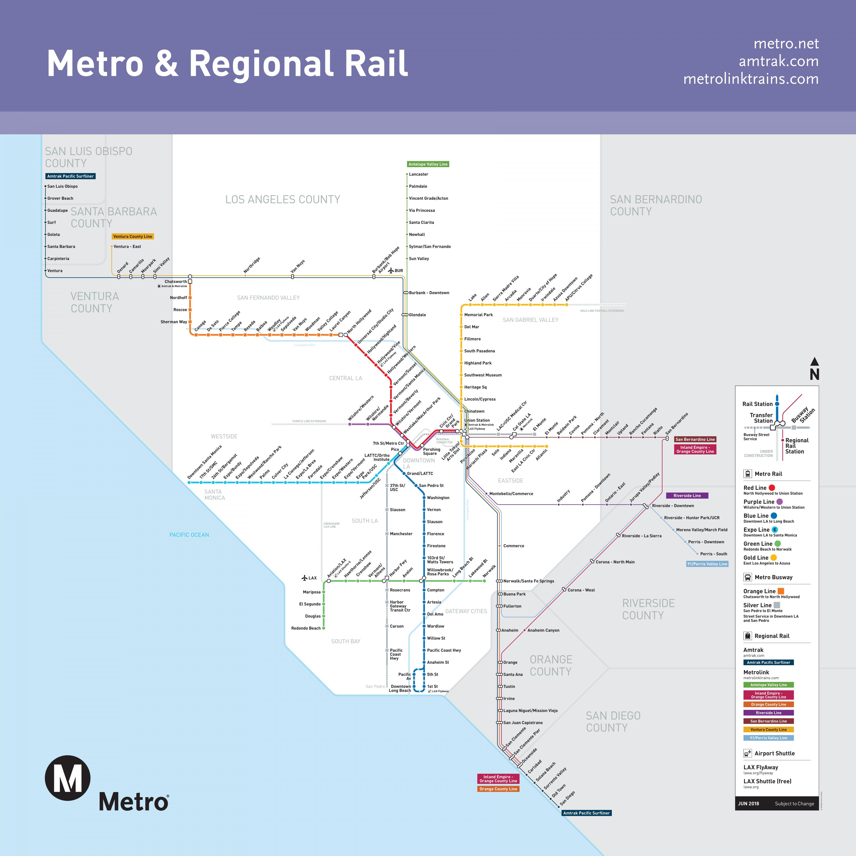
With 4 million inhabitants, LA is the centre of a metropolitan area which is home to some 14 million people within a narrow stretch of land between the Pacific Ocean and the Santa Monica and San Gabriel Mountain ranges in Southern California. After all streetcar lines had been closed down by 1963, LA became the model for a car-friendly city. Finally in the 1980s, the county and region decided to return to rail-based public transport and to build a network of metro and light rail lines. The current system of LA metro rail as its shown in the map has a total length of ~170 km (05/2016), with two subway lines (Red & Purple Line) and four largely grade-separated LRT lines (Blue, Green, Gold and Expo Lines).
LA metro rail is home to one of the country best public transportation networks, including subways, light-rail, buses and shuttles to nearly every corner of the Greater Los Angeles area map. The Los Angeles Tourism & Convention Board is making it easier than ever to discover LA without a car. Car Free L.A. features a series of self-guided "car free" vacation itineraries that offer a new way to experience the hidden gems of L.A. diverse neighborhoods via foot, bike and Metro.
The Metro Rail network of LA map consists of two subway lines, four light-rail lines and two express bus lines. Six lines converge in Downtown. Red Line The most useful for visitors. A metro rail linking Downtowns Union Station to North Hollywood. Purple Line Subway line between Downtown LA, Westlake and Koreatown; shares six stations with the Red Line. Expo Line Light-rail line linking USC and Exposition Park with Culver City and Santa Monica to the west and Downtown LA.