
search
LA metro map
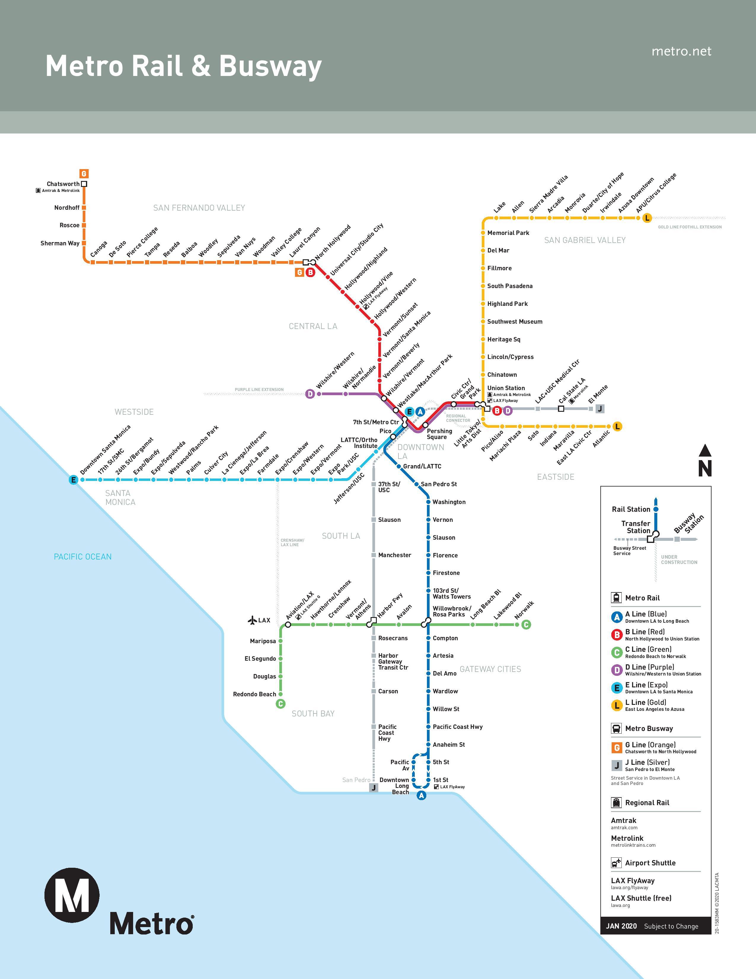
Metro map la. LA metro map (California - USA) to print. LA metro map (California - USA) to download. LA public transit system is a veritable anthill where everything goes every which way. But efficiency is not always one of its major strengths, despite several companies operating in this megalopolis.The strangeness of LA metro is that there are only 6 metro rail lines in the map and there are also metro liner which are actually buses operating on the same principle as the LA subway, i.e. one stop at each station: Orange Line,Silver Line.
LA is one of the best provided cities in the map of the United States in terms of public transport, with subways, light rail systems, buses and shuttles on almost every corner of the city and its metropolitan area. The LA Convention and Visitors Bureau makes it even easier for you to travel around Los Angeles without a car. Car Free LA metro offers a series of recreational routes that provide a new way to discover the hidden treasures of LA different neighborhoods on foot, by bicycle and by Metro.
The Metro Trip Planner of LA is a great tool to use when planning your itinerary in LA. This tool provides detailed instructions on the best way to get to and from a point as shown in the map. You can also download the Go Metro LA mobile application to help you get around the city. All tickets start at the basic rate of $1.50. Depending on your needs, other options may be more advantageous than this one-way fare: the Metro Day Pass at $5 and the 7-Day Pass at $20. For the LA Metro Rail lines and the Orange Line of the Metro Busway lines, single trips and passes must be charged on a Metro TAP card. This is a plastic card that must be kept on hand to be used as often as necessary.
The LA metro is a railroad network that opened on July 14, 1990. It includes 6 lines: blue, red, purple, gold, expo and green. LA metro ticket prices range from $1 to $352 depending on the service (reduced fares apply). It serves, among others, Hollywood and Disneyland as well as the airport thanks to a shuttle that is located near the green line. Its lines will expand between 2019 and 2023. Connections to other means of public transport via EZ Pass are also possible. The LA stations in the map are open daily from 4:00 am to 1:00 am.
Originally, LA metro had a rail network that had been owned by Pacific Electric and LA Railways for over 50 years. Profits were declining due to trains being replaced by buses and the removal of many tracks in 1963. In the 1970s, people demanded the return of trains because of the intensity of automobile traffic. Red Line of LA Metro Rail was the first to build a subway. The last subway line in the map to be built was the Blue Line. The subway opened to the public on July 14, 1990.