
search
Metro gold line map
LA metro gold line map. Metro gold line map (California - USA) to print. Metro gold line map (California - USA) to download. A northern LRT route from Union Station to Pasadena, the metro gold line, was opened in July 2003. The metro gold line was originally planned as the northern part of the Metro Blue Line, and runs along a former railway corridor from Los Angeles map to Claremont. The metro gold line is mostly separated from road traffic with a few level crossings. At Union Station it departs from one of the former railway platforms, while the Metro Red/Purple Line is underground. Before and after the Highland Park station, it runs at relatively low speed on a reserved lane along Marmion Way.
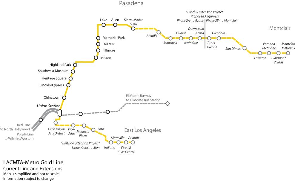
There is a short tunnel in old Pasadena, between Del Mar and Memorial Park stations of the metro gold line. Some 500 m beyond Memorial Park station the metro gold line gets aligned in the median of freeway I-210 up to its terminus at Sierra Madre Villa map. Normally P2000 Siemens 2-unit trains are used on the metro gold line.
The metro gold line was later extended towards the east from Union Station map, with stations at Little Tokyo/Arts District, Pico-Aliso, Boyle Heights Mariachi Plaza, Soto, Indiana, Maravilla, East L.A. Civic Center and Pomona/Atlantic. This 9.6 km metro gold line includes a short 2.7 km tunnel section with two underground stations. It opened in Nov. 2009. The metro gold line was further extended eastwards from Sierra Madre Villa to Azuza, adding 18.4 km and 6 stations. In the next stage, another 19.8 km will be added and bring the metro gold line via Pomona to Montclair (2025/26).